Showing posts with label Geography. Show all posts

Friday, 17 April 2015

Location of Nuclear Fuels

Location of Nuclear Fuels


Uranium and Thorium are the two most important mineral which are used to generate nuclear energy. Uranium is very common mineral produced to generate nuclear energy. Uranium is generally found in the crust of the earth. Uranium is a silver white metal in the actinide series in the periodic table. (Wiki says Actinide series encompasses 15 metallic chemical elements with atomic number from 89 to 103. Not important for our discussion)

When it comes to reserves Australia has the highest amount of reserves of Uranium with 31% followed by Kazakhstan 12%, Russia 9%, Canada 9%, Nigeria 8% and South Africa 5%. But when it comes to production of Uranium, Kazakhstan tops with 34% followed by Canada 19%, Australia 11%, Namibia 9%, Nigeria 8% and Russia 7%. 

Apart from reserves Uranium is also obtained by recycling of Plutonium and used Uranium. It is very easy to obtained Uranium from recycling of Plutonium rather than using used Uranium. Uranium can also be obtained by re-enriching depleted Uranium. Russia is very efficient in re-enriching depleted Uranium.

Thorium is a potential substitute of Uranium. Although it is currently not used as a nuclear fuel, but it has greater potential to become a nuclear fuel in near future. Thorium can not be used directly as a nuclear fuel. Thorium is first converted to a fissile Uranium (U233) by capturing a neutrons in a CANDU reactor (Canada Deuterium Uranium Reactor) . CANDU reactor is specially designed to use Thorium as in generating nuclear energy. 

Thorium is more commonly distributed in the crust of the earth than the Uranium. Although exact knowledge of its distribution is not available but it is believed that the highest amount of reserves are present in Australia, USA, Turkey, India,Venezuela and Brazil.

Indian Scenario :

India has very little amount of Uranium available with it. According to Department of Atomic Energy, current reserve of Uranium is India is around 2 lac tonnes. Highest amount of Uranium reserves are present in Andhra Pradesh followed by Jharkhand and Meghalaya. Production of Uranium is banned in Meghalaya due to social and cultural sentiments of Garo, Khasi and Jayantiya tribes. Some of the prominent reserves are:
Jharkhand:

  • Jaduguda
  • Bhatin
  • Turamdih
  • Bagjata
  • Narwapahar
Andhra:
  • Tumalpalle
  • Koppunuru
  • Sikar
  • Yadgir
  • Gogi
  • Wahkut
One interesting thing is that India has substantial amount of Thorium reserves. Thorium is found in form of Thorium Oxide in Monazite ore. Monazite ore is found in beach and rivers sands. Highest amount of Monazite in  the world is found Pallakad and Kollam districts of Kerala, Vishakhapattanam and Mahanadi Deltas in Odisha. Odisha has the richest reserves of Thorium followed by Andhrapradesh, Tamil Nadu, Kerala, West Bengal and Jharkhand.

Unlike the Coal and Petroleum, Nuclear is a clean and green source of energy. As concerns for global warming are high Nuclear provides an alternative to the conventional sources of energy.


For any suggestion, query or any demand contact us at risingyouthteam@gmail.com or you can contact our admin directly at pn.borse@gmail.com


Sources DOPT, WIKI, nrc.gov, eia.gov, npcil.nic.in

Tuesday, 13 May 2014

Why there is no cyclone at the equator

WHY THERE IS NO CYCLONE AT THE EQUATOR


The Coriolis force acts perpendicular to the Pressure gradient force. The Pressure gradient force is perpendicular to the Isobars. The higher the Pressure gradient force, the more is the Velocity of the wind and larger will be the deflection due to Coriolis force in the direction of the wind. As a result of these two forces operating perpendicular to each other, in low pressure areas, the wind blows around the low pressure, and cyclones are created. But at the Equator, Coriolis force is zero and wind blows perpendicular to the Isobars. The low pressure zone gets filled instead of getting intensified. That is why there is no cyclone at the Equator.

Source: NCERT: Fundamentals of Physical Geography.  11th class

Thursday, 9 May 2013

Something About Tamil Nadu

Something About Tamil Nadu

Rivers

Arani, Palar, Penniyar, Manimukta, Vaigai (This River is Eastern Extension of Periyar river), Cauvery, Chittar, 

Lakes:

Pulicut Lake( share with Andhra),  Kilvelli lake, Kollidam, Stanley Res., Krishnaraj Sagar Res,, Bhavani Sagar Res., Shatnur Res.

Eastern Ghat:

Javedi Hills, Shevaroy Hills, Panchamalai Hills

Western Ghat:

Palani Hills, Sirumalai Hills, Varushnad Hills

Agriculture:

Rice, Cotton Yarn, Sugarcane, Tea and Coffee

Industry:

  • Siriculture in Kanchipuram, Vellore and Pallavaram Districts
  • Automobile and Pharma industries in Ennore
  • Aluminium and Iron industries in Salem
  • Automobile industry in Coimbatore
  • Textile Industry in Erode
  • Cement Industry in Dindigul
  • Madurai is called Coffee Capital of India
  • Cement and Cotton Industries in Virudhnagar
  • Firework industries in Shivkashi
  • Artificial port in Chennai
  • Coal and Iron is imported from Indonesia and Australia through Ennore Port
  • Thoothukkudi: Important port for export

Wildlife:

  • Vedanthangal: Bird Sanctuary
  • Mudumalai: Tiger Reserve
  • Kalkad: Tiger Reserve
  • Neyyar: Wildlife Sanctuary


Saturday, 4 May 2013

Some Important Straits of the World

Some Important Straits of the World


Strait of Bab-el Mandeb: 

It is between Yemen and Eritrea and joins Red sea and Arabian Sea

Suez Canal:

Is is between Egypt and Israel and joins Mediterranean and Red Sea

Strait of Malacca:

It is between Singapore and Sumatra and joins Indian Ocean and Pacific Ocean

Makassar:

It is between Celebes Islands and Borneo Islands in Pacific Ocean

Bering Strait:

It is between Russia and Alaska and joins Bering Sea and Chukchi Sea

Strait of Hormuz:

It is between Iran and Oman 

Gilbraltar:

It joins Atlantic ocean and Mediterranean Sea

Magellan Strait: 

It is in the Southern part of Chile


Friday, 1 March 2013

Something About Andaman and Nicobar

Something About Andaman and Nicobar


  • Andaman and Nicobar islands provide highest number of Wildlife Sanctuaries and National parks in India
  • It has Bay of Bengal on Western Side and Andaman Sea on eastern Side
  • In northern Andaman, there is Coco Island which belongs to Myanmar and is an area of dispute between India and Myanmar
  • Narcondam Island in western part of North Andaman is an Extinct Volcano
  • Andaman and Nicobar Islands are the extension of Eastern Himalayas (Purvanchal), That is why they are continental island. In western Himalayas they are part of specially Arkan Yoma and Peg Yoma ranges in Myanmar.
  • Barren Island in Middle Andaman is the only active Volcano in India
  • Havelock Island in Middle Andaman is important for Heavy Biodiversity and many endemic species
  • Sentinel is the tribe of Southern Andaman, Jarawa is the tribe of Northern Andaman and was in controversy in recent times
  • Duncan Passage is between Southern Andaman and Little Andaman
  • Mount Harriet in Duncan Passage is a National Park
  • Saddle Peak is the Highest peak of Andaman and Nicobar Islands
  • Ten Degree Channel is between Little Andaman and Car Nicobar.
  • Nancowry Island in Nicobar Island group was worst affected by Tsunami
  • Katchall Island in Nicobar is having huge deposits of Petroleum
  • Andaman and Nicobar Islands have all types of Coral Reefs
  • Indira Point in Great Nicobar is the Southern most part of India 


Saturday, 9 February 2013

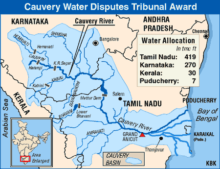
Interesting Facts about Cauvery River

Interesting Facts about Cauvery River


We all know about the facts relating to dispute of the Cauvery river. But UPSC is always one step ahead of our thinking, it will never ask about the dispute. So let see what are the other facts which are ignored and can be asked:
Cauvery River rises from Kurg Plateau in Karnataka and the source is Talla Cauvery

Cauvery Delta:

  • It is the only example of Quadrilateral Delta in the world
  • This delta is the home of many religious places like: Thanjavur, Tiruchchirappalli, Tiruvarur
  • Most famous is Thanjavur for Great Raj Raja Temple (Chola Temple )
  • Two very famous reservoirs on this delta are: Willingdon Reservoir and Kolli dam
  • Manimukta, Vellar, Gomukta and Kullar rivers drain themselves in delta part of Cauvery River

Some very Famous Reservoirs in cauvery river basin are: Krishnaraj Sagar(Karnataka), Bhavani Sagar(Tamil Nadu), Stanley Reservoir.
Charmaraj Sagar Reservoir is over Arkavati River, which is the tributary of Cauvery

Left Hand Tributaries of Cauvery:

  • Hemvati and Yagachi: They meet Cauvery at Krishnaraj Sagar Reservoir, which is very famous for hydro project and a tourism destination called Vrindavan Garden
  • Shimsha river, Arkavati River

Right Hand Tributaries:

  • Lakshman Tirtha: Meets at Krishnaraj Sagar
  • Kabbani, Svarnavati, Amravati and Noyil


 Panchaimalai Hills are between Cauvery and Kollar River

Wednesday, 6 February 2013

Something About Southern U.S.

Something About Southern U.S.


Appalachian Mountains:

  • These mountains are in eastern part of U.S.
  • These mountains are famous for world's largest reserev of Bitruminus Coal
  • Tennessee River originates from here, which is famous for Oldest Multipurpose Hydro Power Project

Ozark Plateau:

  • This plateau is in the Southern Part of U.S.
  • This area is Intensive Cotton Growing Area of U.S.
  • Two very famous rivers Mississippi and Missouri originates from here
  • These two rivers are the only rivers in the world which provide "Bird Foot" delta, because of the deposition of sediments in the base of the mouth
  • New orieans is a place on the delta of Mississippi and Missouri Rivers, which become famous for BP oil crisis in 2012
  • New Oriens is also the place which is the most affected area by Hurricane
Florida State in south eastern part is also a highly affected area by Hurricanes and Tornado
Gulf of Mexico in south eastern part is a very good producer of Shrimps    

Monday, 4 February 2013

Something About Central Africa

Something About Central Africa


  • The very famous river in Central Africa is Congo River, which originates from Democratic Republic of Congo
  • Congo river is providing the largest amount of Pleasure Diamond 
  • Boyoma Falls is on Congo River in Democratic Republic of Congo, it is also known as Stanley Waterfall
  • Ubangi River, which is the tributary of Congo, provides the natural boundary between Democratic Republic of Congo and Central African Republic

Kattanga Plateau:

  • This plateau  is Democratic Republic of Congo
  • This plateau  is rich in Copper, Manganese, and Silver
  • Here is one famous railway of Africa named Tanzara Railway from Kattanga plateau to Dar es Salaam in Tanzania
  • Another railway is Benguela railway from Kattanga plateau to Benguela in Angola

Bie Plateau: 

It is in Angola is famous for Centrifugal Drainage Pattern also known as Radial Drainage Pattern

Okvango Swamps:

It is in Botswana. It is the World's largest inland drainage pattern. It is also hub of largest number of Savana grassland animals.Two rivers drained here are Cuando and Cubango . This area is also home of Bushmen Tribes

Lake Chad:

It is very famous lake in Central Africa. It is shared by four countries: Chad, Cameroon, Niger and Nigeria. This lake is drained by Cheri River, which originates from Central African Rebulic.


Mount Cameroon in is the only active Volcano in Africa


Friday, 1 February 2013

Part-II-World Geography in Short

Part-II-World Geography in Short

In last article i covered Hot Wet Equatorial Climate, Monsoon, Savana and Hot Deserts (http://chitarkont.blogspot.in/2013/01/world-geography-in-short.html)
Now in this article i will cover further climates

Mediterranean Climate (Warm Temperate)

  • Latitude: 30 to 45oc N and S on western Margins of Continents
  • Mean Temperature: 20-25oc
  • Average Rainfall: 20-30 inches
  • Vegetation: Short trees with small brad leaves, Mainly Xerophytic plants due to less rainfall, Oaks, Some Evergreen Coniferous plants in High latitudes,, Shrubs and Bushes, Laurels 
  • Crops:   Citrus Fruits like Orange, Lime lemons, Cereals and Wine Making, Various Types of Nuts, Grapes
  • Regions: Regions Bordering Mediterranean Sea, California, South Western Africa(Cape Town), South Western Australia

Temperate Climate (Steppe)

  • Latitude:  Remote Areas from Maritime away from tropics
  • Mean Temperature: 10 to 15oc
  • Average Rainfall: 10 to 20 inches
  • Vegetation: Treeless Grass
  • Crops: Wheat and Maize
  • Tribal: Kirghiz, Kazakhs and Kalmuk
  • Regions: Eurasia, Russian Plains, Hungary, North American Plans, Mongolia, Argentina, Uruguay, Grasslands of South Africa, Downs of Australia

China Type (Warm Temperate)

  • Latitude: 30 to 50 N and South on Eastern Coasts
  • Mean Temperature: 10-15oc
  • Average Rainfall: 25 to 60 inches
  • Vegetation: Evergreen, Deciduous and Coniferous in different latitudes
  • Crops: Rice, Corn,Cotton, Tobacco, Sugar Cane
  • Regions: Eastern China, South Eastern U.S.A, Paraguay-Uruguay Basin, Western South Africa, South Easter Australia, Northern NewZealand   

British Type (Cool Temperate)

  • Latitude: 40 to 60 N and S on western margins
  • Mean Temperature: 10oc
  • Average Rainfall: 20 to 40 inches
  • Vegetation: Deciduous, Hardwood, Temperate Eucalyptus and Conifers on different Latitude and Topography 
  • Crops: Wheat, Barley and Fruits like: Apples, Pears and Plums, Potatoes, Beet Sugar
  • Regions: North Western Europe, New Zealand, Chile, Tasmania, Rocky Mountains of U.S.A

Siberian Climate (Cool Temperate)

  • Latitude: 55 to 70 only in Northern Hemisphere
  • Mean Temperature: Most of the time below freezing point
  • Average Rainfall: 15 to 25 inches
  • Vegetation: Mostly Coniferous Evergreen 
  • Crops: No crops only lumbering is done on the name of economic activities
  • Regions: Most parts of Russia, Middle and Eastern Europe, Canada, Some parts of Alaska

Arctic or Polar Climate:

  • Latitude: Polar Region
  • Mean Temperature: most of the time below freezing level
  • Average Rainfall: Only snow fall, Some time rainfall with 10 inch yearly average
  • Vegetation: Tundra
  • Crops: No Crops
  • Tribal: Eskimos in Canada and Alaska
  • Regions: Alaska, Northern Canada, Greenland, northern Russia, Antarctica

Thursday, 31 January 2013

World Geography in Short

 World Geography in Short

Hot Wet Equatorial Climate:

  • Latitude: 5o  to 10o north and south
  • Mean temprature:  27oc 
  • Average Rainfall: 100 inches
  • Vegitation: Tropical Rain Forest
  • Crops: Rubber, Cocoa, Oil palm, Coconut, Sugar, Coffee Tea, Tobacco, Bananas
  • Tribals: Orang Asli of Malasiya, Pygmies or Congo Basin
  • Regions: Malasiya, Northern Andes, Kenya 

Tropical Mansoon and Tropical Marine Climate:

  • Latitude: Not Fixed
  • Mean Temprature: 25-35oc
  • Average Rainfall: Varies between 20 to 400 inches in different latitudes and also depend on topography
  • Vegitation: Mostly Deciduos type Tropical Monsoon Forests
  • Crop: Padi, Maize, Wheat, Millet, Gram and Beans, Sugar Cane, Jute,Cotton, Spices and Bananas
  • Regions: Indian Subcontinent, Northern Australia, Myanmar, Thailand, Laos, Cambodia

Savanna or Sudan Climate:

  • Latitude: Confined between the two tropics, between equatorial forest and hot desert
  • Temperature: 21 to 32oc High duranal Range
  • Average Rainfall: 20 to 50 inches
  • Vegitation: Tall Grass and Short Trees(deciduos), Thorny Scrub
  • Crops: Maize, Milet, Corn, Groundnuts, Bananas and Beans, Cotton and Tobacco
  • Tribals: Masai of Kenya and Tanzania, Hausa of Nigeria
  • Regions: West Africa(some parts), East Africa (some parts), Some Parts of Brazil and Northern Australia

Hot Dessert:

  • Latitude:15 to 30oc N and S and Western Part of the Continents (Exception are Gobi and Turkestan Desert)
  • Temperature: 30 to 50oc
  • Average Rainfall: 0 to 10 inches
  • Vegitation: Grass, Scrub, Herbs, Weeds Roots or Bulbs (Xerophytic or Drough Resistant scrubs)
  • Crops: Wheat, Cotton and Maize only near any river basin like Nile
  • Tribals: Bushmen of Kalahari and Bindibu of Australiya
  • Regions: Great Australian Desert, Arabian Desert, Mexcan Desert, Kalahari Desert, Namib Desert, Thar Desert, Iranian Desert

In Next article other Climate (Mediterranean, Temperate, Siberian, Tundra and Polar) will be covered