Thursday, 26 September 2013

WORLD FOOD PROGRAMME

WORLD FOOD PROGRAMME


OBJECTIVE:

The UN World Food Programme was established in 1960 with objectives of Preparation for emergencies, restoration and rebuilding of lives after emergencies, reduction of chronic hunger and malnutrition and help countries reduce hunger by capacity building.

THREATS ASSESSED BY WFP:

Poverty, uneven food distribution, natural disaster, deforestation and low education levels are listed among the threats to food security by WFP.

FOCUS AREAS:

Reduction of Child Mortality, Improvement of maternal health, control and eradication of diseases and enabling environment stability in agricultural operations.

WORKING MECHANISM:

The programme uses food as an incentive to help the poor to gain education, provide healthcare and work to build assets.

WFP IN INDIA:

In India WFP aims to combat malnutrition and invest in human resources, help improve immediate food security for selected target groups, maximize the active participation of women, advocate joint forest management, help strengthen distribution channel for local food grain, increase agriculture production and create employment

Saturday, 14 September 2013

INDIAN GREEN BUILDING COUNCIL

INDIAN GREEN BUILDING COUNCIL


Definition of Green Building:

"A green building is one which uses less water, optimises energy efficiency, conserves natural resources, generates less waste and provides healthier spaces for occupants, as compared to a conventional building."

Vision

To enable a sustainable built environment for all and facilitate India to be one of the global leaders in sustainable built environment by 2025.

Concept of Green Homes

Indian Green Building Council (IGBC) Green Homes is the first rating programme developed in India, exclusively for the residential sector. It is based on accepted energy and environmental principles and strikes a balance between known established practices and emerging concepts. The system is designed to be comprehensive in scope, yet simple in operation. 

Benefits

  • Energy saving 20 to 30%
  • Water Saving 30-50%
  • Enhanced air quality
  • Excellent day lighting
  • Health and Wellbeing of occupants
  • Conservation of scare natural resources

Eligibility

IGBC Green Homes Rating System is a measurement system designed for rating new residential buildings which include construction categories such as 
  • Individual Homes
  • High rise residential apartments
  • Gated Communities
  • Row Houses
  • Existing residential buildings which retrofit and redesigned in accordance with the 
  • IGBC Green Homes criteria
The project team can evaluate all the possible points to apply under the rating system using a suitable checklist. The project can apply for IGBC Green Homes certification if it can meet all mandatory requirements and achieve the minimum required points. 


Concept of Green Building Townships


IGBC continuously works to provide tools that facilitate the adoption of green building practices in India. The development of 'IGBC Green Townships Rating System' is another important step in this direction.

The rating system is designed to address large developments and it is mandatory to include residential development as part of the township. Some typical examples of large scale developments are integrated townships, satellite cities, gated communities, campuses with multiple buildings etc.

Concept of Green Building SEZ


Indian Green Building Council(IGBC) has developed green building rating programmes to cover commercial, residential, factory buildings, etc., Rating programmes would help projects to address all aspects related to environment and is an effective tool to measure the performance of the building/ project.

IGBC along with the Ministry of Commerce and Industry (MoCI) has prepared the Green SEZ guidelines. IGBC has further developed IGBC Green SEZ Rating System as an extension of the Green SEZ guidelines which encourages the projects to exceed the requirements of many codes and standards. IGBC Green SEZ Rating System is a voluntary and consensus based programme. 

The rating system has been developed based on materials and technologies that are presently available. The objective of IGBC Green SEZ is to facilitate the creation of energy efficient, water efficient, healthy, comfortable and environmentally friendly SEZ

The rating system evaluates certain credit points using a prescriptive approach and other credits on a performance based approach. The rating system is evolved so as to be comprehensive and at the same time user-friendly. 

Thursday, 9 May 2013

Something About Tamil Nadu

Something About Tamil Nadu

Rivers

Arani, Palar, Penniyar, Manimukta, Vaigai (This River is Eastern Extension of Periyar river), Cauvery, Chittar, 

Lakes:

Pulicut Lake( share with Andhra),  Kilvelli lake, Kollidam, Stanley Res., Krishnaraj Sagar Res,, Bhavani Sagar Res., Shatnur Res.

Eastern Ghat:

Javedi Hills, Shevaroy Hills, Panchamalai Hills

Western Ghat:

Palani Hills, Sirumalai Hills, Varushnad Hills

Agriculture:

Rice, Cotton Yarn, Sugarcane, Tea and Coffee

Industry:

  • Siriculture in Kanchipuram, Vellore and Pallavaram Districts
  • Automobile and Pharma industries in Ennore
  • Aluminium and Iron industries in Salem
  • Automobile industry in Coimbatore
  • Textile Industry in Erode
  • Cement Industry in Dindigul
  • Madurai is called Coffee Capital of India
  • Cement and Cotton Industries in Virudhnagar
  • Firework industries in Shivkashi
  • Artificial port in Chennai
  • Coal and Iron is imported from Indonesia and Australia through Ennore Port
  • Thoothukkudi: Important port for export

Wildlife:

  • Vedanthangal: Bird Sanctuary
  • Mudumalai: Tiger Reserve
  • Kalkad: Tiger Reserve
  • Neyyar: Wildlife Sanctuary


Saturday, 4 May 2013

Some Important Straits of the World

Some Important Straits of the World


Strait of Bab-el Mandeb: 

It is between Yemen and Eritrea and joins Red sea and Arabian Sea

Suez Canal:

Is is between Egypt and Israel and joins Mediterranean and Red Sea

Strait of Malacca:

It is between Singapore and Sumatra and joins Indian Ocean and Pacific Ocean

Makassar:

It is between Celebes Islands and Borneo Islands in Pacific Ocean

Bering Strait:

It is between Russia and Alaska and joins Bering Sea and Chukchi Sea

Strait of Hormuz:

It is between Iran and Oman 

Gilbraltar:

It joins Atlantic ocean and Mediterranean Sea

Magellan Strait: 

It is in the Southern part of Chile


Thursday, 18 April 2013

UN Convention on the Law of the Sea


UN Convention on the Law of the Sea


The issue of varying claims of territorial waters was raised in the UN in 1967 by Arvid Pardo, of Malta, and in 1973 the Third United Nations Conference on the Law of the Sea was convened in New York. In an attempt to reduce the possibility of groups of nation-states dominating the negotiations, the conference used a consensus process rather than majority vote. With more than 160 nations participating, the conference lasted until 1982. The resulting convention came into force on November 16, 1994, one year after the sixtieth state, Guyana, ratified the treaty.

The convention introduced a number of provisions. The most significant issues covered were setting limits, navigation, archipelagic status and transit regimes, exclusive economic zones (EEZs), continental shelf jurisdiction, deep seabed mining, the exploitation regime, protection of the marine environment, scientific research, and settlement of disputes.


Internal Water

Covers all water and waterways on the landward side of the baseline. The coastal state is free to set laws, regulate use, and use any resource. Foreign vessels have no right of passage within internal waters.
Territorial waters


Territorial Water

Out to 12 nautical miles (22 kilometres; 14 miles) from the baseline, the coastal state is free to set laws, regulate use, and use any resource. Vessels were given the right of innocent passage through any territorial waters, with strategic straits allowing the passage of military craft as transit passage, in that naval vessels are allowed to maintain postures that would be illegal in territorial waters. "Innocent passage" is defined by the convention as passing through waters in an expeditious and continuous manner, which is not "prejudicial to the peace, good order or the security" of the coastal state. Fishing, polluting, weapons practice, and spying are not "innocent", and submarines and other underwater vehicles are required to navigate on the surface and to show their flag. Nations can also temporarily suspend innocent passage in specific areas of their territorial seas, if doing so is essential for the protection of its security.


Archipelagic waters

The convention set the definition of Archipelagic States in Part IV, which also defines how the state can draw its territorial borders. A baseline is drawn between the outermost points of the outermost islands, subject to these points being sufficiently close to one another. All waters inside this baseline are designated Archipelagic Waters. The state has full sovereignty over these waters (like internal waters), but foreign vessels have right of innocent passage through archipelagic waters (like territorial waters).


Contiguous zone

Beyond the 12-nautical-mile (22 km) limit, there is a further 12 nautical miles (22 km) from the territorial sea baseline limit, the contiguous zone, in which a state can continue to enforce laws in four specific areas: customs, taxation, immigration and pollution, if the infringement started within the state's territory or territorial waters, or if this infringement is about to occur within the state's territory or territorial waters.[4] This makes the contiguous zone a hot pursuit area.


Exclusive economic zones (EEZs)

These extend from the edge of the territorial sea out to 200 nautical miles (370 kilometres; 230 miles) from the baseline. Within this area, the coastal nation has sole exploitation rights over all natural resources. In casual use, the term may include the territorial sea and even the continental shelf. The EEZs were introduced to halt the increasingly heated clashes over fishing rights, although oil was also becoming important. The success of an offshore oil platform in the Gulf of Mexico in 1947 was soon repeated elsewhere in the world, and by 1970 it was technically feasible to operate in waters 4000 metres deep. Foreign nations have the freedom of navigation and overflight, subject to the regulation of the coastal states. Foreign states may also lay submarine pipes and cables.


Continental shelf

The continental shelf is defined as the natural prolongation of the land territory to the continental margin’s outer edge, or 200 nautical miles (370 km) from the coastal state’s baseline, whichever is greater. A state’s continental shelf may exceed 200 nautical miles (370 km) until the natural prolongation ends. However, it may never exceed 350 nautical miles (650 kilometres; 400 miles) from the baseline; or it may never exceed 100 nautical miles (190 kilometres; 120 miles) beyond the 2,500 meter isobath (the line connecting the depth of 2,500 meters). Coastal states have the right to harvest mineral and non-living material in the subsoil of its continental shelf, to the exclusion of others. Coastal states also have exclusive control over living resources "attached" to the continental shelf, but not to creatures living in the water column beyond the exclusive economic zone.


Aside from its provisions defining ocean boundaries, the convention establishes general obligations for safeguarding the marine environment and protecting freedom of scientific research on the high seas, and also creates an innovative legal regime for controlling mineral resource exploitation in deep seabed areas beyond national jurisdiction, through an International Seabed Authority and the Common heritage of mankind principle.
Landlocked states are given a right of access to and from the sea, without taxation of traffic through transit states.

Monday, 15 April 2013

Indian Nuclear Arrangements

Indian Nuclear Arrangements


Department of Atomic Energy, India has been pursuing the nuclear program in 3 stages

1st Stage :

  • It is the only stage in commercial domain
  • In this stage the Pressurized Heavy Water Reactor (PHWR)is developed
  • Natural Uranium (Uranium 235) is used  as fuel
  • Heavy Water is used as moderator or coolant
  • The Nuclear Power Corporation of India ltd (NPCIL) is responsible for design, construction and operation of nuclear reactors
  • PHWRs are at Kundankulam, Kakrapar(Gujrat), Rawatbhata(Rajasthan)

2nd Stage:

  • This stage is in Demostration Stage
  • In this stage Fast Breeder Reactors (FBS) are developed 
  • Plutonium is produced by irradiation of Uranium 238
  • Liquid Sodium is used as Coolant
  • Indira Gandhi Center for Atomic Research (IGCAR)  is engaged in design and development of reactors
  • Prototype FBR is  working at Kalpakkam
  • Bhartiya Nabhikiya Vidyut Nigam (BHAVINI) is implementing the project at Kalapakkam

3rd Stage:

  • This stage is in Development Stage
  • This stage is based on Thorium-Uranium-233 Cycle
  • Uranium-233 is obtain by irradiation of Thorium
  • In this stage Advanced Heavy Water Reactor(AHWR) is Developed at BARC
  • AHWR is first time developed in the world
  • A research reactor KAMINI is operational at Kalapakkam


In all the 3 stages only 1st is in commercial use, 2nd stage is in demonstration, and the 3rd stage is in developmental stage
 

Sunday, 7 April 2013

Biosphere Reserves of India

Biosphere Reserves of India


Biosphere Reserves of India

  • Great Rann of Kutch Gujarat
  • Gulf of Mannar, Tamil Nadu
  • Sundarbans West Bengal
  • Cold Desert, Himachal Pradesh
  • Nandadevi, Uttarakhand
  • Nilgiri Biosphere Reserve, Tamil Nadu,Kerala andKarnataka
  • Dihang-Dibang, Arunachal Pradesh
  • Pachmarhi Biosphere Reserve, Madhya Pradesh
  • Seshachalam Hills, Andhra Pradesh
  • Simlipal, Odisha
  • Achanakamar -Amarkantak, Madhya Pradesh,Chhattisgarh
  • Manas, Assam
  • Khangchendzonga, Sikkim
  • Agasthyamalai Biosphere Reserve, Kerala, Tamil Nadu
  • Great Nicobar Biosphere Reserve, Andaman and Nicobar Islands
  • Nokrek, Meghalaya
  • Dibru-Saikhowa, Assam
  • Panna, Madhya Pradesh

Biosphere Reserves Recognized by UNESCO

  • Achanakmar-Amarkantak Biosphere Reserve, Chhattisgarh, Madhya Pradesh
  • Gulf of Mannar Biosphere Reserve, Tamil Nadu
  • Nanda Devi Biosphere Reserve, Uttarakhand
  • Nilgiri Biosphere Reserve, TamilNadu, Kerala, Karnataka
  • Nokrek Biosphere Reserve, Meghalaya
  • Pachmarhi Biosphere Reserve, Madhya Pradesh
  • Simlipal Biosphere Reserve, Odisha
  • Sundarbans national park, West Bengal

Potential Sites for Biosphere Reserve

  • Namdapha, Arunachal Pradesh
  • Thar Desert, Rajasthan
  • Little Rann of Kutch, Gujarat
  • kavalam, Assam
  • Kanha, Madhya Pradesh
  • North Islands of Andaman Andaman & Nicobar
  • Abujmarh, Madhya Pradesh
  • Chintapalli, Andhra Pradesh
  • Lakshadweep Islands, Lakshadweep
  • Singbhum

Monday, 1 April 2013

SABLA

SABLA


The original name of this scheme is Rajiv Gandhi Scheme for Empowerment of Adolescent Girls (RGSEAG)
This scheme covers out of school and school going Adolescent girls under 11 to 18 age group
This scheme has two components: Nutritional Components and Non Nutritional Component

Nutritional Component:

  • Take home ration or hot cooked meal for out of school going girls under 11 to 14 years age
  • Also take home ration or hot cooked meal for school going girls under 14 to 18 years age

Non-Nutrition Component:

  • For out of school girls under 11 to 18 years of age
  • They are provided Iron&Folic acid supplement, Health check up, nutrition and health education, counselling/guidance on family welfare, adolescent reproductive sexual health, child care practices and life skill education, and accessing public services

Vocational Training:

  • For all girls under 16 to 18 age

Other provisions:

  • Anganwadi are the implementation agencies
  • 100% central assistance under non-nutritional components
  • 50% central assistance under nutritional components


Friday, 22 March 2013

Disability and Govt. Policy

Disability and Govt. Policy


India is a Country which posses all types of disabilities like Visual, Hearing, Speech, Locomotors and Mental Disabilities.
The constitution of India, specially the articles 17,21,21A,14 ensure equality, freedom, justice and dignity of all individuals and implicitly mandate an inclusive society for all including the persons with disabilities.

Some international conventions, of India is signatory:

  • Declaration on the Full Participation and Equality of People with Disabilities in the Asia Pacific Region
  • Biwako Millennium Framework: For action towards an inclusive, barrier free and rights based society.
  • UN Convention on Protection and Promotion of the Rights and Dignity of Persons with Disabilities.

Some National Mechanisms:

National Policy for Persons with Disabilities 2005:

  • It focuses on prevention of desabilities and physical and economic rehabilitation of persons with disabilities 

Persons with Disabilities(Equal opportunities, Protection of rights and Full Participation) Act, 1995

  • Focuses on Education, Employment, Vocational Training , Creation of Barrier free environment, Rehabilitation Services, Institutional Services and Supportive Social Security Measures like unemployment allowance and grievance redressal machinery.

National Trust for Welfare of Persons with Autism, Cerebral Palsy, Mental Retardation and Multiple Disabilities Act, 1999

  • India is the only country in the world to have legislation for Autism
  • This act focuses on extending support to registered organisations providing need based services
  • Also focuses on to evolve procedures for appointment of legal guardians for persons with disabilities.

Rehabilitation council of India:

Statutory body setup under the Rehabilitation Council of India Act, 1992. Its working areas are

  • Standardization and Regulation of Training Courses for profession trainers
  • Recoginsation of institutions and universities running training courses in area of rehabilitation of disabled within and outside the country
  • Promotion of research in rehabilitation and special education
  • Maintenance of Central Rehabilitation Register for Professionals possessing the recognised rehabilitation qualification
  • Encouragement of continuing rehabilitation education programmes

Other National Mechanisms:

  • Office of Chief Commissioner for Persons with Disabilities
  • National Handicapped Finance and Development Corporation
  • Schemes for Assistance to Disabled Persons for Purchase/Fitting of Aids and Appliances
Some Institutes in Field of Rehabilitation and Special Education

  • National Institute for Visually Handicapped, Dehradun
  • National Institute for Orthographically Handicapped, Kolkata   
  • Ali Yavur Jung National Institute for Hearing Handicapped, Mumbai
  • National Institute for Mentally Handicapped, Secunderabad
  • National Institute for Rehabilitation Training and Research, Cuttack
  • Institute for Physically Handicapped, New Delhi
  • National Institute for Empowerment of Persons with Multiple Disabilities, Chennai
  • Artificial Limb Manufacturing Corporation of India, Kanpur


Monday, 18 March 2013

Judicial Arrangements in India

Judicial Arrangements in India


National Judicial Academy:

  • Registered in 1993 under Societies Registration Act 1860
  • Provides training to Judicial Officers
  • Academy is located at Bhopal with registered office at Delhi

Arrangement for free legal aid to Poor:

1)National Legal Service Authority (NALSA)

  • Constituted under Legal Service Authorities Act 1987
  • Provides Free Legal Aid to eligible person
  • Organises Lok Adalats for amicable settlement of disputes
  • Eligible Person: Women, Children, SC,ST, Industrial Workmen, Victims of disaster and violence, Disabled Person, Person in Custody, Victims of Trafficking

2)Lok Adalats:

  • Statutory Status under Section 19 of Legal Service Authorities Act 1987
  • Handles only Civil Cases
  • Its decisions are final and binding and person can not appeal against the decision of Lok Adalat
  • Permanent Lok Adalats are available specially for the cases related to Public Utility Services

Bar Council of India:

  • Under  Advocates Act 1961

Law commission of India:

  • It is a non statutory body constituted time to time in every 3 years
  • Current Chairman is  D.K. Jain

Scheduled Caste and Govt. Schemes

Scheduled Caste and Govt. Schemes


  • Ministry of Social Justice and Empowerment is the nodal authority 
  • Present population of scheduled caste in the country is 16.2%

National Scheduled Castes Finance and Development Corporation(NSCFDC)

  • Under the Ministry of Social Justice and Empowerment. 
  • Provides the credit facilities to person of SC living below double the poverty lines limits.
  • Provides 40000 per year for rural and 55000 per year for urban for income generation activitia

National Commission for Scheduled Castes

  • It is a constitutional body under article 338
  • Monitors the safeguard and review issue concerning welfare
  • It has the power of Civil Court

Protection of Civil Rights Act 1955

  • This act is made under the article 17 of constitution and provides punishment for practice of untouchability

Scheduled Castes and Scheduled Tribes(Prevention of Atrocities) Act 1989

  • Prevents the commission of offence by a person other than SC&ST against SC&ST
  • Acts extends to whole of India except J&K

Educational Development

  • Post Matric Scholarship
  • Pre- Matric Scholarship for Children engaged in unclean Occupation
  • Under Rajiv Gandhi National Fellowship Scheme, which was launched under 11th Five Year Plan, Scholarship is Provided for Higher Educations like Mphil, Phd and research degree. This scheme is implemented by UGC
  • Reservation
  • Free Coaching for competitive exams
  • Babu Jagjivan Ram Chhatrawas Yojana

National Overseas Scholarship Scheme

  • Assistance in Institution fee, Monthly Maintenance allowance, Incidental journey premium, annual Contingency allowance
  • For only one child of same parents. 
  • For under 35 years of age
  • Only for master degree and Phd in Engineering, Technology and Science

Special Central Assistance to Scheduled Caste sub Plan:

  • Central Govt gives the assistance to Sub plan for SC by State govt.
  • For Economic Development of SC BPL people
  • 50% of assistance for subsidy (10000per beneficiary)
  • 10% for infrastructure development of village having 50% SC population
  • 15% of assistance for SC Women

Scheduled Caste Development Corporation:

  • Identifying Eligible SC Family
  • Motivating them to incorporate economic development scheme
  • Sponsoring Scheme to financial institutions for credit support
  • Providing financial support in form of Marginal money at low interest rate
  • Subsidy to reduce repayment liabilities 
  • Providing necessary tie ups with Poverty alleviation programs

Other Schemes:

  • National Scheduled caste finance and Development Corporation
  • Self Employment Scheme of Rehabilitation of Manual Scavenging
  • Voluntary Organisations 
  • National Safai Karmachari Finance and Development Corporation
  • Dr. Ambedkar Foundation  


Friday, 1 March 2013

Something About Andaman and Nicobar

Something About Andaman and Nicobar


  • Andaman and Nicobar islands provide highest number of Wildlife Sanctuaries and National parks in India
  • It has Bay of Bengal on Western Side and Andaman Sea on eastern Side
  • In northern Andaman, there is Coco Island which belongs to Myanmar and is an area of dispute between India and Myanmar
  • Narcondam Island in western part of North Andaman is an Extinct Volcano
  • Andaman and Nicobar Islands are the extension of Eastern Himalayas (Purvanchal), That is why they are continental island. In western Himalayas they are part of specially Arkan Yoma and Peg Yoma ranges in Myanmar.
  • Barren Island in Middle Andaman is the only active Volcano in India
  • Havelock Island in Middle Andaman is important for Heavy Biodiversity and many endemic species
  • Sentinel is the tribe of Southern Andaman, Jarawa is the tribe of Northern Andaman and was in controversy in recent times
  • Duncan Passage is between Southern Andaman and Little Andaman
  • Mount Harriet in Duncan Passage is a National Park
  • Saddle Peak is the Highest peak of Andaman and Nicobar Islands
  • Ten Degree Channel is between Little Andaman and Car Nicobar.
  • Nancowry Island in Nicobar Island group was worst affected by Tsunami
  • Katchall Island in Nicobar is having huge deposits of Petroleum
  • Andaman and Nicobar Islands have all types of Coral Reefs
  • Indira Point in Great Nicobar is the Southern most part of India 


Monday, 18 February 2013

Science of Indian Crops: Part-I

Science of Indian Crops: Part-I


Since few years UPSC is asking about conditions of growing and asking the name of crops. Now let see the science of crops:

Rice:

Condition: High Heat and High Humidity
Temperature: 25 to 300C
Altitude: From sea level to 2500 meters
Annual rainfall: 150CM, (if deficient rain, then irrigation can also  be useful)
Soil: deep fertile clayey or loamy
Areas: Delta Region, Ganga plains, river valleys, Coastal Region
Major Producing States: West Bengal, Punjab, UP, Andhra, Tamil Nadu

Wheat: (RABI)

Temperature: 10 to 150C (Winter), 21 to260C(Summers)
Condition: Cool Climate with Moderate Rainfall
Annual rainfall: 75CM, (if deficient rain, then irrigation can also  be useful)
Areas: Well drained areas,
Soil: Fertile friable loam
Major Producing States: UP, Punjab, Haryana, Rajasthan, Madhya Pradesh

Maze:(KHARIF)

Temperature: 20-300C
Condition: Warm Climate with moderate rainfall
Annual rainfall: 50-100CM, (if deficient rain, then irrigation can also  be useful)
Soil: Well Drained alluvial or red loams free from coarse materials rich in nitrogen
Major Producing States: Madhya Pradesh, Andhra Pradesh, Karnataka, Rajasthan, UP

Gram(RABI)

Temperature: 20-250C
Annual rainfall: 40-50CM, (if deficient rain, then irrigation can also  be useful)
Soil: Loamy 
Major Producing States: Madhya Pradesh, UP, Rajasthan, Haryana, Maharastra

Cotton:(Kharif)

Temperature: 21-300C 
Condition: High temperature with moderate rainfall
Annual rainfall: 50-100CM, (if deficient rain, then irrigation can also  be useful)
Soil: Mostly Black Soil
Major Producing States: Maharastra, Gujrat, Andhra, Punjab, Haryana

Jute:

Temperature: 25 to 350C 
Condition: Hot and Humid Climate
Annual rainfall: 100-150CM
Areas: Deltas
Soil: Light Sandy and Clayey Loams
Major Producing States: West Bengal, Bihar, Assam, Odisha, Meghalay


We will see further more crops in next article


Wednesday, 13 February 2013

Crime and Criminal Tracking Network and Systems

Crime and Criminal Tracking Network and Systems


About CCTNS

CCTNS is a Mission Mode Project under the National e-Governance Pan of Govt of India. CCTNS aims at creating a comprehensive and integrated system for enhancing the efficiency and effectiveness of policing through adopting of principle of e-Governance and creation of a nationwide networking infrastructure for evolution of IT-enabled-state-of-the-art tracking system around 'Investigation of crime and detection of criminals'. 

Objectives of 'CCTNS'

The objectives of the Scheme can broadly be listed as follows:
1. Make the Police functioning citizen friendly and more transparent by automating the functioning of Police Stations.
2. Improve delivery of citizen-centric services through effective usage of ICT.
3. Provide the Investigating Officers of the Civil Police with tools, technology and information to facilitate investigation of crime and detection of criminals.
4. Improve Police functioning in various other areas such as Law and Order, Traffic Management etc.
5. Facilitate Interaction and sharing of Information among Police Stations, Districts, State/UT headquarters and other Police Agencies.
6. Assist senior Police Officers in better management of Police Force
7. Keep track of the progress of Cases, including in Courts
8. Reduce manual and redundant Records keeping

Benefits to Law Enforcement Agencies:

  • Quick Retrieval of information for criminal investigation
  • Exchange of information between various police stations and higher offices through dedicated connectivity
  • Crime analytics and Business Intelligence
  • Reduction in Manual Record maintenance 

Future Benefits to Citizens

  • Facility to register complaints online and track their Status
  • Submission of requests for issuance of NOCs, Clearances and Permits
  • Enabling citizens to download forms and certificates
  • Missing/Found information for vehicles/Children/Property 


Monday, 11 February 2013

Geo-strategic Position of Indian and Look South Policy

Geo-strategic Position of Indian and Look South Policy


India's position is on the head of Indian Ocean and a leader in Indian Ocean region. Indian Ocean is the busiest route in the world, extents from Atlantic Ocean to Pacific Ocean. When it comes to the security of security of this route, world look at India. Now let see what is the geo-strategic position of India
  • India is at the position, from where it provides the zone of conversion of West Asia, East Asia and Central Asia
  • Global politics is changing due to recession in the world and shifting towards the South-East Asia. And when it comes to engaging with South East Asia, India provides the most reliable source to be utilized
  • India provides the Largest potential market in terms of population
  • Due to U.S.A's pivot to Asia policy, U.S. wants to utilize India for negotiation with South East Asia. That is why U.S. is engaging India in Quadrilateral dialog between India, U.S., Japan, Australia.
  • Due to security threat in South China sea and Conflict with China, ASEAN countries are engaging more and more with India, due to cultural proximity with India and India provides a counter leadership against China.

India's Look South Policy:

  • India has always followed the brotherly relation policy with neighboring countries.
  • Before the disintegration of USSR, India's position was isolated one and India's foreign relations were based on certain types of ideology and support to various types of organisations.
  • After the disintegration of USSR, India's economy was liberalized and we started engaging with South East Asia and later with South Asia.
  • India had over reaching influence on the foreign policies of Nepal, Bhutan and Maldives, which during 2001 criticized by many nations like Shrilanka and Bangladesh
  • To correct this criticism India adopted the Look South policy in 2008.
  • The main aim of this policy is the peaceful relations.
  • India also wants to increase the trade ties with south Asia because of the increasing influence of China in Nepal, Bangladesh, Myanmar, Pakistan and Maldives. 
  • In 2011 and 12, India encouraged Pakistan also to increase economic ties
  • India wants good support of South Asian countries in organisations like IORARC, SAARC, RIMS,Commonwealth Nations, World Bank, IMF,WTO.

Saturday, 9 February 2013

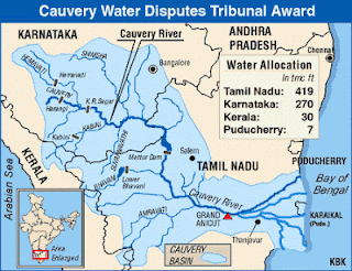
Interesting Facts about Cauvery River

Interesting Facts about Cauvery River


We all know about the facts relating to dispute of the Cauvery river. But UPSC is always one step ahead of our thinking, it will never ask about the dispute. So let see what are the other facts which are ignored and can be asked:
Cauvery River rises from Kurg Plateau in Karnataka and the source is Talla Cauvery

Cauvery Delta:

  • It is the only example of Quadrilateral Delta in the world
  • This delta is the home of many religious places like: Thanjavur, Tiruchchirappalli, Tiruvarur
  • Most famous is Thanjavur for Great Raj Raja Temple (Chola Temple )
  • Two very famous reservoirs on this delta are: Willingdon Reservoir and Kolli dam
  • Manimukta, Vellar, Gomukta and Kullar rivers drain themselves in delta part of Cauvery River

Some very Famous Reservoirs in cauvery river basin are: Krishnaraj Sagar(Karnataka), Bhavani Sagar(Tamil Nadu), Stanley Reservoir.
Charmaraj Sagar Reservoir is over Arkavati River, which is the tributary of Cauvery

Left Hand Tributaries of Cauvery:

  • Hemvati and Yagachi: They meet Cauvery at Krishnaraj Sagar Reservoir, which is very famous for hydro project and a tourism destination called Vrindavan Garden
  • Shimsha river, Arkavati River

Right Hand Tributaries:

  • Lakshman Tirtha: Meets at Krishnaraj Sagar
  • Kabbani, Svarnavati, Amravati and Noyil


 Panchaimalai Hills are between Cauvery and Kollar River

Friday, 8 February 2013

Recent Crisis in Africa

Recent Crisis in Africa

Democratic Republic of Cango:(Former Colony of Belgium) 

DRC is the third biggest country in Africa. This country has been in conflict since almost 2 decades.
  • Rebel Group: M23(Movement of March 23), Allegely backed by Uganda and Rawanda
  • Intention: M23, marks the rsurrection of prior militia, the National Congress for Defence of People(CNDP), which was integrated into the national armed forces in 2009. In April 2012, for CNDP members mutinied, accusing the national government of President Joseph Kablia rneging on previous agreements.
  • Peace keeping mission: Monusco (United Nations Organisation Stabilisation Mission in DRC)

Mali:(Former Colony of France)

  • Rebel Group: Tuareg and Ansardine backed by Al-Queda
  • Intension: Demand for Saperate nation by the name "Azavo"
  • Peace kepping Mission: Afisma (African Led International Mission in Mali)

Central African Republic:(Former Colony of France)

  • Rebel Group: Seleka
  • Intention: They are charging that government of country which seized power in a coup in 2003, is not abiding by terms of peace deals signed between 2007 and 2011
  • Peace Keeping Mission: Fomac (The Multinational Force of Central Africa)

Southern Sudan:

South Sudan Declared Independent itself from Sudan in July 2011. After the independece, there is conflict between the two countries, over the Oil resources, which mostly kept by South Sudan. The U.N. Peace keeping mission UNMISS (U.N. Mission in South Sudan ), is working for peace here.

Somalia:

  • Rebel Group: Al-Shabab, Backed by Al-Qaueda
Somalia has been driven by civil war since the collapse of the dictatorship of Mohammed Slad Barre in 1991. In september 2012, a Monitored transitional goveremnedt Central Government headed by Mr. Mohamud, who was elected by a nominated Parliament.
Now Al-Shabab is almost defeated, and rebuilding process of Somalia has started.

Thursday, 7 February 2013

The Reality of Urban Migrants in India

The Reality of Urban Migrants in India


It is an irony of Indian Economy that thousands of rural poor have to leave their home and live on roads without shelters in the big cities. In India, daily thousands of migrants come to Mumbai, Delhi, Bangalore and Punjab from U.P., Bihar, Jharkhand and North East, to search for job, because they do not have any livelihood in their respective rural areas. India's Population has increased from 286 million in 2001 to 377 million in 2011 and is expected to go up to 600 million by 2030.
UNESCO-UNICEF publication on internal migrants: "Internal Migration and Social Protection: The Missing Link." has analysed problems of urban migrants in India. Here are some problems of Urban Migrants in India

Problems of Urban Migrants in India:

  • In govt Slum Rehabilitation Schemes, a beneficiary is eligible only if he has Address proof of that city. So a migrant does not have the address proof, so he has to live without house, on the road.
  • To have a ration card, one must have to have an address proof, so the migrant also has to live without subsidized food
  • Seasonal Migrants who migrate when there is no crop season, this affects the education of their children, so it becomes sure that the next generation is also going to be a non skilled worker and a migrant
  • Migrants are vulnerable to occupation health hazards, and non-communicable diseases 
  • Migrants are not accepted by the city people and always seen as a criminal.
  • Low wages
  • No access to toilets, because there is lack of facility of toilets for the people who live without shelters
  • According to controversial criteria for BPL people given by Planning Commission, there are only 8% people are BPL in Delhi, But in reality there are 30% people are living in slums and 4% are living on the Road  
  • Similarly 53% people are living in slums and 8% on roads in Mumbai
  • Supreme Court has ordered of providing ration card to homeless people without address proof, but this has not been properly implemented yet 
Now we see, what can be the solution for the problems of urban migrants:

Possible Solutions:

  • Redefine the BPL Criteria and 50% weightage should be given to lack of basic amenities, schools and hygine
  • Ration cards to homeless people
  • More and more investment in Rural Areas, so these people need not migrate for livelihood
  • Reservation for migrants in Housing Schemes like JNURM  
  • Employment Schemes for urban areas like MGNREGS 

Wednesday, 6 February 2013

Something About Southern U.S.

Something About Southern U.S.


Appalachian Mountains:

  • These mountains are in eastern part of U.S.
  • These mountains are famous for world's largest reserev of Bitruminus Coal
  • Tennessee River originates from here, which is famous for Oldest Multipurpose Hydro Power Project

Ozark Plateau:

  • This plateau is in the Southern Part of U.S.
  • This area is Intensive Cotton Growing Area of U.S.
  • Two very famous rivers Mississippi and Missouri originates from here
  • These two rivers are the only rivers in the world which provide "Bird Foot" delta, because of the deposition of sediments in the base of the mouth
  • New orieans is a place on the delta of Mississippi and Missouri Rivers, which become famous for BP oil crisis in 2012
  • New Oriens is also the place which is the most affected area by Hurricane
Florida State in south eastern part is also a highly affected area by Hurricanes and Tornado
Gulf of Mexico in south eastern part is a very good producer of Shrimps    

Monday, 4 February 2013

Something About Central Africa

Something About Central Africa


  • The very famous river in Central Africa is Congo River, which originates from Democratic Republic of Congo
  • Congo river is providing the largest amount of Pleasure Diamond 
  • Boyoma Falls is on Congo River in Democratic Republic of Congo, it is also known as Stanley Waterfall
  • Ubangi River, which is the tributary of Congo, provides the natural boundary between Democratic Republic of Congo and Central African Republic

Kattanga Plateau:

  • This plateau  is Democratic Republic of Congo
  • This plateau  is rich in Copper, Manganese, and Silver
  • Here is one famous railway of Africa named Tanzara Railway from Kattanga plateau to Dar es Salaam in Tanzania
  • Another railway is Benguela railway from Kattanga plateau to Benguela in Angola

Bie Plateau: 

It is in Angola is famous for Centrifugal Drainage Pattern also known as Radial Drainage Pattern

Okvango Swamps:

It is in Botswana. It is the World's largest inland drainage pattern. It is also hub of largest number of Savana grassland animals.Two rivers drained here are Cuando and Cubango . This area is also home of Bushmen Tribes

Lake Chad:

It is very famous lake in Central Africa. It is shared by four countries: Chad, Cameroon, Niger and Nigeria. This lake is drained by Cheri River, which originates from Central African Rebulic.


Mount Cameroon in is the only active Volcano in Africa


Saturday, 2 February 2013

India-Russia: An Age Old Friendship

India-Russia: An Age Old Friendship

Introduction:

Diplomatic relationship between India and Russia are 65 years old since India's independence. Russia has been India's most valuable and trusted defense and economic partner. India and Russia moved to strategic level partnership in oct 2000. It has been stated by both the countries from time to time that deepening the friendship and cooperation is top priorities of their foreign policies. Russia has been supporting India's intentions for membership in UNSC and SCO.

Channels of Relationship:

  • Common Research and Development
  • Direct Contact between Business Communities
  • Cultural Ties
  • Humanitarian Ties
  • Science and Technological Ties
  • Defense and Military Support
  • Partnership in all Spheres

Joint Research and Development Projects:

  • Multirole Transportation Aircraft (T 50)
  • Brahmos Supersonic Missile 
  • T90 Bhishma Tank
  • Nuclear Submarine INS Arihant

Russian Support to India 

  • Sharing of Weapon Technology
  • Leasing out Nuclear Submarine INS Chakra
  • MIG and Sukhoi Aircrafts
  • Battle Tanks
  • And many more
  • Support in Kudankulam plant
  • Steel Industry in Bhilai
  • Many Navy Ships 

Potential Economic Areas

  • Steel Industry
  • Hydrocarbon Industry
  • Chemical Industry
  • Pharmaceuticals 
  • Car& Aircraft Manufacturing
  • Information Technology
  • Biotechnology

Disputed Issue between two Countries

  • India's Refusal to waive Civil Nuclear Liability for units III and IV of Kudankulam Nuclear Plant
  • India's Failure to Secure Russian Telecom Company Sistema's massive investment in Joint Venture Sistema Shyam Teleservice Ltd
  • Delay in Delivery of Aircraft Carrier INS Vikramaditya 
  • High Tax imposed on Imperial Energy , an Indian company operating in Russia

Recent Agreements during Putin's Visit to India

  • Two Satelite agreements with Glonass
  • Agreement on operating Ranging Station that will help accurately fixing the location of satelites
  • Direct trade in energy sector in both upstream and downstream
  • $2bn Kremlin backed investment fund
  • Pact of Russian Direct Investment Fund with State Bank of India
Russia is stressing hard in recent times for more friendly cooperation with India due to
  • Ukraine's increasing influence in weapon industry
  • Opening up of Russian economy, India becomes the most attractive destination for investment
  • U.S.A's pivot to Asia
  • Strategic power of India in Indian Ocean and South Asia
Russia is currently heading G20 and SCO, it increases the chances of India's getting membership of SCO

Friday, 1 February 2013

Part-II-World Geography in Short

Part-II-World Geography in Short

In last article i covered Hot Wet Equatorial Climate, Monsoon, Savana and Hot Deserts (http://chitarkont.blogspot.in/2013/01/world-geography-in-short.html)
Now in this article i will cover further climates

Mediterranean Climate (Warm Temperate)

  • Latitude: 30 to 45oc N and S on western Margins of Continents
  • Mean Temperature: 20-25oc
  • Average Rainfall: 20-30 inches
  • Vegetation: Short trees with small brad leaves, Mainly Xerophytic plants due to less rainfall, Oaks, Some Evergreen Coniferous plants in High latitudes,, Shrubs and Bushes, Laurels 
  • Crops:   Citrus Fruits like Orange, Lime lemons, Cereals and Wine Making, Various Types of Nuts, Grapes
  • Regions: Regions Bordering Mediterranean Sea, California, South Western Africa(Cape Town), South Western Australia

Temperate Climate (Steppe)

  • Latitude:  Remote Areas from Maritime away from tropics
  • Mean Temperature: 10 to 15oc
  • Average Rainfall: 10 to 20 inches
  • Vegetation: Treeless Grass
  • Crops: Wheat and Maize
  • Tribal: Kirghiz, Kazakhs and Kalmuk
  • Regions: Eurasia, Russian Plains, Hungary, North American Plans, Mongolia, Argentina, Uruguay, Grasslands of South Africa, Downs of Australia

China Type (Warm Temperate)

  • Latitude: 30 to 50 N and South on Eastern Coasts
  • Mean Temperature: 10-15oc
  • Average Rainfall: 25 to 60 inches
  • Vegetation: Evergreen, Deciduous and Coniferous in different latitudes
  • Crops: Rice, Corn,Cotton, Tobacco, Sugar Cane
  • Regions: Eastern China, South Eastern U.S.A, Paraguay-Uruguay Basin, Western South Africa, South Easter Australia, Northern NewZealand   

British Type (Cool Temperate)

  • Latitude: 40 to 60 N and S on western margins
  • Mean Temperature: 10oc
  • Average Rainfall: 20 to 40 inches
  • Vegetation: Deciduous, Hardwood, Temperate Eucalyptus and Conifers on different Latitude and Topography 
  • Crops: Wheat, Barley and Fruits like: Apples, Pears and Plums, Potatoes, Beet Sugar
  • Regions: North Western Europe, New Zealand, Chile, Tasmania, Rocky Mountains of U.S.A

Siberian Climate (Cool Temperate)

  • Latitude: 55 to 70 only in Northern Hemisphere
  • Mean Temperature: Most of the time below freezing point
  • Average Rainfall: 15 to 25 inches
  • Vegetation: Mostly Coniferous Evergreen 
  • Crops: No crops only lumbering is done on the name of economic activities
  • Regions: Most parts of Russia, Middle and Eastern Europe, Canada, Some parts of Alaska

Arctic or Polar Climate:

  • Latitude: Polar Region
  • Mean Temperature: most of the time below freezing level
  • Average Rainfall: Only snow fall, Some time rainfall with 10 inch yearly average
  • Vegetation: Tundra
  • Crops: No Crops
  • Tribal: Eskimos in Canada and Alaska
  • Regions: Alaska, Northern Canada, Greenland, northern Russia, Antarctica